Thursday, 02 August 2007 Hancock Loop, New Hampshire
After visiting Cannon last week I was down to 6 non-winter peaks left on the NH 4000-footers list. Kevin had so far visited only 13 peaks and Chelsea had only Jackson to her credit. The Hancocks would make a nice two-fer for all of us. We arrived at the hairpin turn on the Kancamagus Highway by 8:45, changed into our boots, admired the view of the Osceolas, and were hiking at 9:00. The Hancock Notch Trail began with a daredevil crossing of the Kanc from the inside corner of the hairpin turn. We were totally blind to traffic so we relied on our ears and bolted across when all sounded quiet. This was the most dangerous part of the whole trip, and we'd survived it. The trail then proceeded very gently. The treadway was nearly as even as a sidewalk and the climbing was easy. We were making excellent time even with frequent water stops. Temps were expected to climb well into the 30s C and we planned to each drain at least one bottle in the first couple miles and refill them before we began our climb up away from the many stream crossings down low.
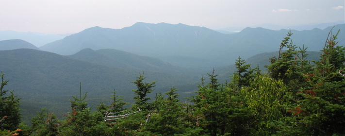
After only 45 minutes we came to our first trail junction where we turned onto the Cedar Brook Trail. I knew we had five crossings on this stretch but I was not certain we would have water higher up. We figured to stop at the fourth crossing and refill our water. The first crossing was of a very nice ledgy section of the brook. There were many herdpaths here, probably from people trying to bypass or make this crossing in high water. It took us some time to determine with of the paths was the actual trail. The crossings were frequent but easy along this part of the trail and we were soon at the fourth where we took a lengthy snack break and pumped water as we'd planned. We soon made another brook crossing before arriving at the start of the Hancock Loop Trail. From here we started to climb more noticeably but we were not yet to the steep sections that make this hike so noteworthy. We soon started to get some glimpses of the Hancocks through the trees. At first we could only view a shoulder of North Hancock, but further down the trail we began to get peeks at the Arrow Slide. Our ascent route would take us to the right of, and roughly parallel to the slide.
We took another water and snack break at the point where the loop splits. We were headed up the North branch and would gain over 1100 ft in less than the 0.7 mi indicated on the sign because the first couple tenths are downhill or flat. As we set out we got another good view of the slide, this time with the north summit just rising over the shoulder of the mountain. We crossed a level spot at a low point that appears to be some kind of runoff channel. Now the real climbing began, but the trip so far had been rather easy so everyone was still feeling fresh and happy. The grade steepened considerably but the footing was actually pretty stable and there were very few huge steps so we were able to maintain a regular steady pace. As we rose our surroundings took on a more high-elevation character, passing through mossy spruce fir and eventually opening up through stunted trees. The thinning canopy allowed for some views of South Hancock when we stopped and faced out from the slope we were climbing. Chelsea and Kevin might have different ideas, but I was thoroughly enjoying the climb. Gaining so much elevation in such a short distance put me in a sort of ascent mode and I would have been happy to continue. The Hancocks are only so high, however, and soon the trail began to level out with continued views through the trees. We contoured along a slope for a short distance and then came around a turn to find the summit sign. Chelsea was happy to have doubled her 4K count. We took the short spur path to a rocky outcrop where we sat for lunch and enjoyed a southerly panorama. We were baking in the sun as we ate and so didn't linger overlong. As we packed up a hiker who'd gotten there before us offered to take a group photo for us with the Osceolas as our backdrop.
We set off along the ridge for the south peak. I don't recall hearing anyone mention what a nice ridge walk this is. At times the woods were open and the carpet green, at other times the stunted evergreens grew thick and held the trail close. Occasionally we would get a sneak preview of our second summit for the day. The descent from the north peak was short and the climb up the south peak was mostly painless as it seemed to take place over several short ups separated by small descents or flats. When we arrived at the summit I was surprised to already be there. We went down to the outlook which opened somewhat to the southeast with Chocorua in the distance. We ate some more lunch as we readied ourselves for the descent which would be every bit as steep as our climb had been. Fortunately it was also as short and provided a last interesting look at the Arrow Slide. We were all quite hot, tired, and sweaty by the time this steep pitch was behind us and were eager to get to some of those stream crossings we'd passed earlier in the day. As we ambled along the lower part of the Hancock Loop Trail we began to parallel a good flowing stream that I'd noted early in the day. At the trail's first approach to the bank there was a miniature pool, just large enough to sit in, and a small waterfall into it that created a frigid little jacuzzi. The water was cold in the way that brings me almost to the point of blacking out with pain before finally losing all sensation. It was a hypothermic fantasy come true. Kevin couldn't stay in long enough to go numb and instead patiently dried out on the gravel bank while Chelsea and I turned blue. We stuck our heads under the waterfall, were visited by a tiny fish, and watched the stream flow away to where it disappeared into the forest. Once we were sufficiently frozen we got out, got our boots back on, and set out for our last bit of walking. When we passed the ledgy stream crossing I knew we were almost home. It had only taken us just over 45 minutes to reach this point in the morning and now it was all down hill. By about 5:30 we were back at the hairpin turn which is not much easier crossing from the outside corner. We dashed across to the parking lot and took a final snack break before heading home. Our hike was about 10 miles total with a vertical gain of 2650 feet.


