Sunday, 29 April 2012 Red Rock Ridge, Maine

A small, mossy cascade crossed early in the hike.
For a while I've been working toward a long hike, in excess of thirty kilometers; and I've been gazing at the obvious loop formed by the Miles Notch, Red Rock, and Great Brook trails on my map for much longer. Having done a few other hikes, taking advantage of a mild winter and an early spring, I decided it was time to increase vertical and distance by doing this loop and by including an out-and-back side trip to Speckled Mountain. As a bonus, the entire route would be new terrain for me.

Trail through Miles Notch
I missed the last turn on the way to the trailhead in Stoneham but caught and fixed the error quickly. The road (the correct road) gradually got narrower and rougher and I was glad to reach the trailhead before it fizzled out entirely. As it happened, this wasn't a worry because the road continued past a gate and was in very good condition beyond the car park. The Miles Notch trail set out following a much older and overgrown road before becoming a faint footpath. I live only about 35km north of here but spring is much more present on this south side of the range than in my dooryard. The forest floor was looking lively with the fresh green foliage of Canada mayflower and other herbaceous plants, and the smell of rich, living soil filled the chilly air. Not far into the hike, after rock-hopping a couple of streams, I met my first painted trillium of the season. I spent some time with the flower before moving on. I soon came upon another stream; it was smaller and probably a tributary to one I'd jumped earlier in the morning. I crossed it at a series of tiny, moss-lined cascades. It was lovely in the morning sun that found its way through the young leaves. In a few weeks this stream will be fully shaded by the trees overhead. The trail continued to climb, its tread obscured by several blowdowns and by piles of last fall's dead leaves. The grade steepened and I noticed that what had once been an open slope was now being closed in by a cliff above on my left and a steep wooded ridge on my right. I was entering Miles Notch. Miles Notch had a wild and gnarly look to it that pleased me. The hardwood trees that filled the notch seemed to be a little more twisted and bent than usual. A small and unrefined stream worked its way around mossy boulders and through the crowns of downed trees. The warm morning grew cold in the notch. What had been a pleasant breeze at the trailhead was now a strong, bone-chilling wind as it squeezed through the narrow pass. Near the height of land I entered the Caribou-Speckled Mtn. Wilderness, and not long after I came to the junction with the Red Rock Trail.

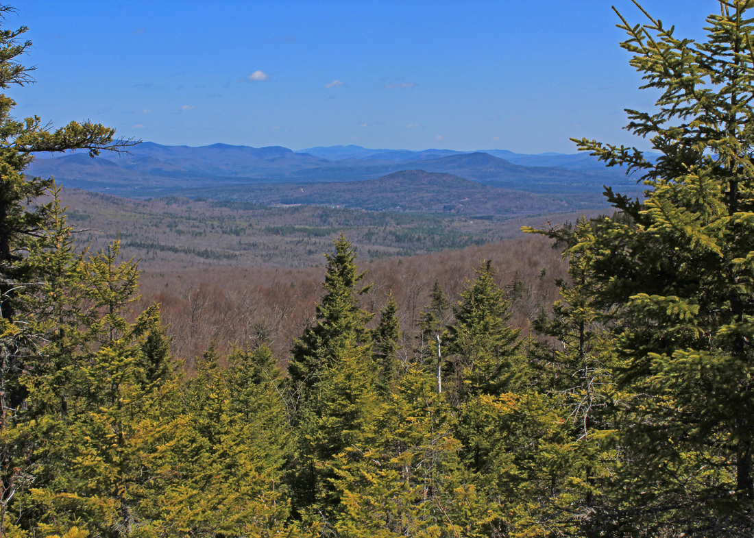
View west from Red Rock Mountain
I turned left at the junction and stepped across the sluggish stream before beginning my climb of Miles Knob. I still moved through open woods, rich with Beech, but began to get in to more sections of evergreen woods as I gained elevation. The trail carried me around the north side of the Knob, not over it, before proceeding northwest along the ridge to Red Rock Mountain. The ridge was fairly easy walking through mixed woods, and the climbs were short-lived. At times I'd get in a wind shadow and enjoy a warm stretch, but it didn't last long. As I neared the top of Red Rock I kept an eye open for a herd path on my left that the WMG said would take me to a grew view. The path was obvious and it took me to a good view over some shrubby trees. From that point, though, I saw a faint and somewhat sketchy path to what might be a more open ledge. I followed it carefully, as a slip could have a very bad outcome. I climbed up a short bit of rock and walked out onto a large, sloping outcrop with a nearly sheer drop to the west. The views here were wonderful from the south-southeast over Kezar Lake to the west over Speckled Mountain to Mt. Washington. I spent a few minutes here enjoying the view before making my way back to the trail. Other ledges along the ridge afforded more views in different directions, but none were as open as this one. Some were just pleasant, sunny places with no view other than the sky.

Woods along Butters Mountain
From Red Rock Mountain the trail worked its way gradually into a col between RR and Butters Mountains. In the col was a tiny pond, probably ephemeral, and it looked like a herd path left the col to head down the northeast side of the ridge, perhaps to connect with the Haystack Notch trail. The climb up Butters was somewhat steep but short. After the initial climb the ridge along Butters rolled along, and I never really knew when I was at the high point. I went through some attractive open woods, here dense with hobblebush, there with a carpet of grass. Other areas moved through lichen, moss, and evergreen. It was along one of the mossy sections that I noticed what I first thought was a scat. I stopped and looked closer...who doesn't like to check out a nice poop on the trail? I think it was, in fact, a pellet. It was full of tiny bones, including one structure that looked like a three-way junction of long bones. Holding the bones was a mass of what looked like feather material, although it might have been fur. I'm guessing an owl produced the pellet, but I have no idea who his unfortunate lunch guest was. The trail began to head down again so I knew Butters was behind me. I came to another blowdown - there had been several along the ridge. this one obscured the faint trail and it took few minutes of scouting to find the trail again. This was my entrance into the sag between Butters and Durgin Mountains. This col was wide and flat and hosted an attractive patch of Indian poke near the junction with the Great Brook trail. I took a short snack here and readied myself for the next climb.

View over the Red Rock Ridge from Speckled
From the junction I continued on the Red Rock trail as it climbed Durgin Mountain. I had expected to notice the climb more but it was fairly easy. Along the way I found myself surrounded by chickadees and was hearing both Black-capped and Boreals. Being rather bolder, the Boreal chickadees came closer , enabling a few quick pictures through the branches. After visiting with the birds for a few minutes I carried on. The drop between Durgin and Speckled was very slight. I began to work my way up Speckled and found it pretty easy climbing at first. Eventually, though, the grade steepened and up I went. I paused partway to consider a short ledge adorned with icy stalactites, a testament to the recent cold weather. I pressed on, crossing some small ledges that told me I was getting closer. I crossed a small but fresh-looking spring and very shortly came to the summit. I had never known that there was a water source so close to the top. It was windy and quite cold at the top. I took my summit photos and then huddled in the lee of one of the firetower foundations while I downed my PB&J in record time. I began my descent, retracing the route I came up, at 2:00. An interesting aspect of backtracking is noticing things that I missed on the way in. As I worked my way down from Speckled I spotted a ledge with a nice view, framed by trees, of the Red Rock Ridge. A little later, in a different bit of ledge, I saw an interesting groove. It was perhaps 4 cm wide and 50 cm long. The rock on either side of it was raised, as if it had been plowed from a softened surface. It didn't look like any glacial striation I'd ever seen. Carrying on, I arrived at the Great Brook junction again and took another short snack-and-photo break.

A high crossing of a branch of Great Brook
After my break I collected myself for the last leg of the journey. The Great Brook trail started out flat but very soon it began to drop steeply off the ridge. The trail was in hardwoods and, therefore, often hidden by deep leaves. More blowdowns helped to further obscure the way. About halfway down the steep part I crossed a sweet little tributary of Great Brook where it tumbled over tiny cascades formed rocks and by roots of nearby trees. Further down was a deeply-furrowed tree with a mossy set of shelf mushrooms arranged neatly in a groove. It looked almost intentional. The trail began to follow Great Brook more closely. Through the sparse leaves many cascades were visible, including a rather large one. At this point, though I was too tired to want to wander through the hobblebush for pictures. This part of the trail would be a worthwhile destination on its own, though, and I hope to someday return. I hopped across the brook at the end of the steep section and enjoyed a more humane descent. There were still a number of small cascades, including one particularly attractive one just next to the trail. The trail now was an assortment of old roads. It was obvious that this land had not long ago been farmed. Although now wooded with small trees, it still maintained a pastoral sensibility. The WMG mentioned an old homesite of the Butters family that I'd been watching for but somehow missed. I realized my mistake when I came to a turn that was two tenths of a mile below the site. It was a flat section so I headed back to look for it. I found it easily this time. A stone wall ran along next to the trail, which was an obvious old road. I climbed over it and spotted the grave marker. Two young Butters children were buried here, or memorialized at least. Just behind it was the stone foundation, with a very large birch growing in the middle of it. I wandered around the perimeter and then headed back down the road. The way got a little confusing after this. There were a few junctions where another road branched off from the one I was following. The description in the guide was written for the ascending hiker, for whom the route would be obvious. Between the map, knowing I would need to cross the river to my left on a bridge, and a few short dead ends, I was able to work my way out to the main road. This was the one I'd driven in on that was gated. I crossed the bridge and strolled along the road for the last few tenths of a mile back to my car.
The hike was 24.3 km with a total climb of about 1300 m. Time was 9:20.
The hike was 24.3 km with a total climb of about 1300 m. Time was 9:20.