Tuesday, 11 August 2009 Howe Brook Falls, Baxter State Park, Maine

Lower south Branch Pond
Kevin and I arrived at South Branch Pond yesterday and spent a lazy afternoon moving in and paddling around a little bit. We had hoped to hike the Traveler Loop today but the forecast was not to my liking as it included a chance of thunderstorms. Instead we decided to hike up the Howe Brook Trail and check out the many small cascades and falls. Our route began with a mile walk along the flat and often muddy Pogy Notch Trail. Shortly before reaching the Howe Brook Trail, the Pogy Notch Trail opens out to the southeast corner of Lower South Branch Pond. We paused to look back toward the campground before moving on.

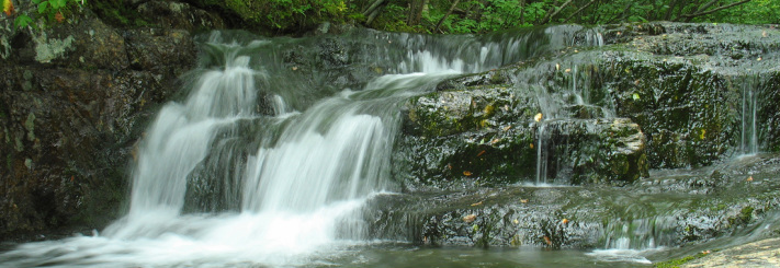
Howe Brook Falls
Turning up the Howe Brook Trail it wasn’t long before we came to many scenic spots. The brook tumbled over drop offs, steps, and chutes into chilly pools and slid over smooth ledges green with moss. After a distance the trail pulled slightly away from the brook, although it was always easily heard. Finally the trail ceased its gradual climb and began to ascend steeply but briefly to the uppermost falls which are around 8 m high by my estimate. We had a snack there looking up at the falls and then climbed a worn path up to the top where the rocky platform was slick with wet moss and lichen and found another small cascade feeding into the larger one. We spent some time exploring up there before heading back down. On the descent we stopped again at several falls and pools, all the while deciding which one to swim in. We opted for the lowermost cascade and pool which had ledges next to it that would be convenient to sit on and dry out after our dip. Another couple of families were already there but there was plenty of room. I got out of my boots, shorts, and shirt and worked my way into the waist-deep water. It was nice and cold. After soaking for several minutes and dunking my head a few times I was getting pretty numb so got out and sat in the sun to dry off. Kevin had still not gotten very far into the water and I figured he wasn’t going to. Then he surprised me by launching himself into the pool. I thought he must have fallen in but he says it was intentional. I don’t know what came over him. Now pleasantly chilled and dried we set back out on the trail and were soon back to camp.


Wednesday, 12 August Traveler Loop, Baxter State Park, Maine

First view of the day, from the Center Ridge Trail
As it happened, the sky only got clearer as yesterday went on and it never rained. It would have been a great day for the Traveler Loop. Today’s forecast was better than yesterday’s had been, calling for only 20% chance of showers and no thunderstorms, and the sky was clear. Unfortunately Kevin was on his way home and so had missed his chance (or dodged a bullet) to hike the Loop with me. I would be hiking it solo today. I got walking by 8:15 with three liters of water, many snacks, a fleece top and bottom and my sleeping bag. I wouldn’t ordinarily have carried the warm gear but the Loop is lightly traveled and reputed to be quite rugged. I figured it made sense to overpack a bit, just in case. The Loop began with the Pogy Notch Trail again but passed by yesterday’s trail, continuing on to the Center Ridge Trail. I reached this junction in only 45 minutes. Turning on the Center Ridge Trail the climbing began and did not relent, gaining over 2200 ft for the next 2 miles. I really enjoyed this trail. Although the trail sign said that the first view would be reached in 0.7 miles I started getting limited views over the pond almost immediately. The trail climbed rather steeply over gravel, small boulders, and short ledges. None of the moves were technical or even particularly difficult but it made the climb interesting. The lower part of the trail moved through low blueberry and other bushes and open stands of red pine. It was really quite pretty. Further up the trail carried me out in the open with views all around, including up toward the Peak of the Ridges, the summit for this portion of the Loop. As I climbed some clouds were developing, mainly to the south, but they didn’t seem too serious so I decided to believe the forecast and kept hiking. At 11:00 I gained the summit and stopped for my first break and snack of the day. I took in some views, Katahdin was prominent in the south, and shot a video of the Traveler Loop - the ridges and summits I would be hiking over before my day was done. As always, the effort looked daunting when I saw it all laid out ahead of me like that, but I’ve hiked enough to know it’s not usually (notice I didn’t say never) as bad as it looks.


View up to the Traveler from the col
The 1.3-mile segment to the Traveler began by scrambling over what my guidebook calls the “Little Knife Edge” and indeed it is reminiscent of the spectacular ridge on Katahdin. This edge though, the ranger and I jokingly called it the Butter-knife Edge, is much shorter and less vertiginous than its better-known kin. Nevertheless it was a fun stretch of trail before crossing through an attractive spruce-fir filled meadow and then entering birch woods in the shallow col between these first two summits. The ascent of the Traveler was at first easy with good footing. Then I emerged onto a scree field that needed crossing. It took a minute to locate the route as it was marked with small cairns which blended in visually with all the other rocks. Once I determined that the trail went pretty much straight across it was fairly easy going. From this point it was not far to the summit of the Traveler which, as the sign indicates, is Maine’s largest volcanic mountain. If the sign wasn’t there it would be easy to tell that something was different about this massif. The rock is obviously not like the rock of Katahdin or even the Whites. Its texture is smooth and shows interesting cleavage patterns. In places where cliffs plunge into the pond its columnar structure is clearly visible. I reached the summit at 12:15 and a quick check of the sky revealed that the clouds had thickened and darkened and might be developing into thunderheads. At this point, however, I had covered nearly half the mileage and much more than half of the vertical gain of the total loop and knew from talking to folks who’d hiked yesterday that the footing ahead of me was much easier than the footing behind me. Although I still had quite a bit of exposed trail there were a few pockets of forest where I could take cover if needed so I decided not to turn back.


A knob that I dubbed Mid-Traveler
The descent of the Traveler down to the low ridge was the toughest part of the trip. The footing was rough, often comprising loose talus that wobbled underfoot. The trail was a bit difficult to follow as the blazes had faded and there was little sign of a treadway. It was actually a quite scenic stretch of trail and I’m sorry now that I didn’t stop for pictures along the way but I had other priorities at the time. The sky was increasingly threatening and I wanted to put this last portion of rough trail behind me - and get to the cover of trees - before the weather opened up. As I descended the talus gave way to smooth ledge which then gave way to a forest of conifers. There I relaxed a bit and enjoyed the barely-trodden trail through the mossy woods. I moved through the woods, still dry and free of thunder, for a short time before beginning to emerge onto open ledge again. I’d barely even noticed any ascent but I had made the minor summit along the Traveler Ridge. The sky hadn’t gotten any worse and I took some time to admire my spectacular surroundings. Behind me stood the Traveler with it’s ceiling of dark clouds, ahead of me rose North Traveler under mostly blue sky. I snacked for a while, enjoying my current favorite hike treat: a chewy peanut butter and chocolate granola bar with a packet of almond butter smeared on top. This treat provides 12g of protein and 22 grams of fat and oh, how I love it. I felt the snack dissolve into my bloodstream. Now I had plenty of energy to burn so I resumed my circumnavigation of the Howe Brook drainage that I’d hiked into yesterday. I crossed over the knob of the ridge and dropped back down, entering a lovely stand of stunted birch. Soon the birch thinned and I emerged onto an increasingly open slope ascending North Traveler. I especially enjoyed this section as the climb was gentle and the “trail” so lightly traveled that it was little more than a cross-country route. Also the sky was beginning to clear off and I could relax my pace and take in the scenery as I climbed. Before I knew it, six hours after leaving camp, I was standing atop my final summit for the day. I spent a good deal of time lounging on the summit, snacking, and taking pictures in all directions.


Thanks to a pile of rocks for holding my camera during this exposure

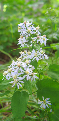
White Aster
After a leisurely half hour or so it was time to head down. From observing the ridgeline down to camp from various points on the loop I expected a mostly gentle descent until the last kilometer and that’s what I got. This final leg headed west down to South Branch Pond. After dropping for a couple minutes I met the first (and only) other hiker of the day. We chatted for a few minutes before I moved on. North Traveler turned out to be a spectacular mountain. The views in all directions were outstanding. Even the views up close were fantastic as I moved through a variety of plant communities and and environments. At first I descended steeply but briefly over small broken rock before entering a narrow band of spruce and fir. I quickly emerged from that into an alpine meadow dotted with small conifers and populated with a variety of shrubs and blooming wildflowers. Looking behind me I could see the summit, to the north I could look over the miniature forest to lakes and more distant peaks. I spent a great deal of time here absorbing my breathtaking surroundings and imaging some of the nearby blooms. While I was concentrating on some white asters I could hear a noise nearby, something snorting, repeatedly. I was so intent on setting up and getting a good picture of the flowers, though, that it didn’t really occur to me that there was a Very Large Mammal...RIGHT behind me. When I finished with the flowers I stood up and turned, startling the large bull moose. He had been within 3 meters of me. He dashed off only a few meters more before stopping to monitor my retreat. I still had my camera in my hand so I snapped pictures as I slowly wandered down the trail. He was magnificent, with a large rack of velveted antlers. Leaving him to his business, the trail opened out into a treeless section of the meadow that was more like a rock garden and then climbed slightly to one of several open, ledgy knobs that would characterize the hike down. This open portion of the meadow between two knobs reminded me quite a bit of the summit of Mt. Clay in New Hampshire with its twin summits serving as bookends to a sub-arctic plant community.


Walking through a stand of gnarled birch
My descent continued into a glade of stunted and gnarled birches, some were not much taller than me despite having thick trunks. Their shade was welcome after spending so much of the afternoon out in the heat of the Sun and I found that reason enough to dawdle through this section. As I was exiting the glad I noticed a worn path off to my right. The ranger had told me about a spring but I thought he was referring to the birch glade along Traveler Ridge, before the climb of North Traveler. I assumed I missed the spring because I never saw it. As it happened, I misunderstood the ranger. I took the short path over to the spring and soaked my head liberally. Its water was clear and very cold. Now I was getting fairly low on the mountain and started to find myself surrounded by heavily laden blueberry bushes. I relieved them of some of their burden as I hiked but I was pretty eager for a swim in the pond below so I didn’t spend too much time grazing. Carol was due the next day and I thought she might like to hike up here so I figured I could pick berries then.

Big Peaked Mountain looks like an interesting summit
The last bit of the descent, and the most difficult, took me over a steep, ledgy, knobby ridge that plunged its south side down into the Howe Brook valley and loomed over Lower South Branch Pond. The rock was quite dry but much of the treadway was covered with gravelly material that was rather like walking on marbles. I took in views of the Traveler, Peak of the Ridges, and Katahdin’s Knife Edge to the south while to the north loomed the cliffy summit ridge of Big Peaked Mountain. Looking down to the southwest and west I had views of both Ponds and could see many people canoeing, cliff-diving, and swimming. I could also see a beaver swimming near a lodge in the Lower pond. I worked my way down into the woods where the steep descent was eased by some well constructed stone staircases. Eventually the trail leveled off and the path presented several sections of the thick gray mud that I’d seen near the campground. Although I wasn’t thrilled about slopping through mud I was too excited about my impending swim to care very much. Finally I came to the junction with the Pogy Notch Trail and from there it was only a few steps to the campground. The last 2.5 miles, although it was the easiest hiking of the whole loop, took me three hours to hike because I spend as much time sight-seeing as hiking. Had I hiked right down at the same pace I’d maintained for the rest of the day I would have finished the hike in about 7:45. I changed into my swimmy shorts at my lean-to and jumped into the pond for a much needed cool down. I climbed out onto the dock to dry in the sun and chatted again with the lone hiker I had seen near the summit. He had just gotten down and showed off his liter of berries that he picked before jumping into the water himself.


Thursday, 14 August 2009 Lower and Upper South Branch Ponds, Baxter State Park, Maine
This morning I was expecting Carol to arrive for the last three-day stretch of my week. I wasn’t sure when she’d get in so I didn’t go far from camp. I got up pretty early, especially for me, and was in a kayak by 7:15 for a cruise around the Lower pond. Nobody else was on the water and the wind was calm and the sky was clear. IAlong the western shore of the pond as I passed a beaver lodge I saw an adult swimming and heard vocalizations coming from the den. She must have young but I couldn’t tell how many. She dove with a splash and came up some distance away. I turned around at the far end of the pond and on my way back two Common Loons surface very close to me, making me sorry that I didn’t have my camera. I paddled away slowly to give them their space but they dove and resurfaced right near my boat again. I watched them for a few minutes before returning to camp. After breakfast I brought my camp chair and a book down to the stoney beach of the pond to wait for Carol who arrived at around 11:00.
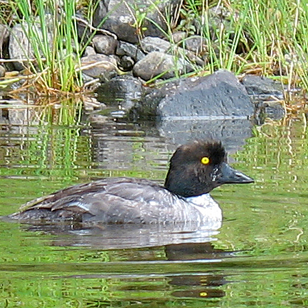
The Traveler Loop was my primary goal for this trip but a secondary goal was to paddle around in the Upper pond. Some years ago I had camped in the lean-to at the southern end of the Upper pond with Carol and Laura but we had hiked in. Fewer years ago we were camped at this campground with Wendy, Bettina, and Chelsea but the wind was high and the water too rough for a trip through the connecting channel. I really wanted to spend some time on the water of Upper South Branch Pond. In the afternoon we took a canoe out and headed that way. There was little wind and our trip to the channel was easy. Rather than use the portage trail we waded through the shallow channel pulling the canoe which we only had to lift a couple of times. The Upper pond is beautiful and was busy. Several groups had gathered on a very steep ledge. A couple of them were fishing but most were jumping from the cliffs from various heights. We paddled around the shore and came to our old lean-to which was unoccupied so we stopped to revisit it and take a break on the bench on the shore. Carol spotted a Yellow-banded Snake which slithered off before I could get a picture. The flowers couldn’t get away so easily and I managed to capture a few with my camera. I wasn’t able to get many images though because I had pretty much filled my memory card over the previous two days. I only had a little room left. The sky was getting darker in places and Carol thought she heard thunder so we set back out. As we paddled back the sky cleared so we stopped hurrying. Back through the channel we were making our way back to camp when we spotted a bird that we think is a female Common Goldeneye.
Friday, 14 August 2009 North Traveler, Baxter State Park, Maine

A garden of lichen
This was my last full day in the park and Carol’s only full day. I had told her about North Traveler and she wanted to climb it. the forecast looked great so at 8:00 we hit the trail. We planned on really taking our time, picking berries, eating berries, and taking pictures. We managed to make this hike take all day, gaining the summit at noon, frittering away an hour there, and spending three hours coming down. My moose was nowhere to be seen but as we neared the bottom we were passed by a family that had just seen a bear only a few hundred meters above us. During the day I did notice a colorful garden of lichen and bunchberry and some purple flowers that I hadn’t seen on Wednesday. I think they are Harebells (Campanula rotundifolia). Our hike was followed by another dip in the pond, supper, and a campfire.