Monday, 12 March 2007
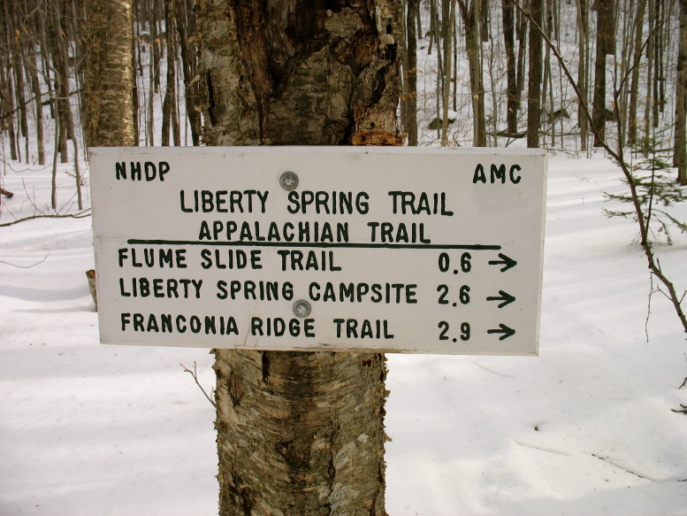
With little more than one week left in calendar winter and only a single 4000-foot mountain summited for this season so far I decided to head out and add another to my list. I would be solo and though warm, winds were expected at elevation. I chose to attempt Mounts Liberty and Flume since I am very familiar with the trail and there is very little exposure. I got to the Flume trailhead at about 8:45 and unsurprisingly there were no other cars in the lot. I got my things together and was walking by 8:50. The Whitehouse Trail connects the car park with the Liberty Spring Trail but I decided to take the bike path (which in winter is a snowmachine trail) which has less elevation change. I was feeling lethargic and nauseous; I never take well to mornings and yesterday's switch to daylight savings time wasn't helping. Still, I expected the effects to subside after an hour or so of walking. I was moving slowly but it wasn't very far to the Liberty Spring Trail which turned right off the buried bike path. Facing into the warm, early morning sun, I expected to start feeling better soon. The trail did its best to help, climbing gently for a good distance before beginning a serious ascent of the ridge, but I was still struggling not to throw up the breakfast that I couldn't eat. A quarter mile up the trail I forced down half a Clif bar and some hot tea. I hiked on with a pathetic pace up the still gentle trail. At 0.6 mile from the bike path I came to the Flume Slide junction and crammed the other half of the bar into my face. While I gnawed on the slightly frozen bar I pondered the Kinsman ridge on the other side of the highway. I had visited those peaks this past summer while recovering from pneumonia. It had been a steep climb and a slow day; today would be too. I put down a little more tea and turned back up the trail. I plodded along knowing that this relatively easy grade wouldn't last much longer.
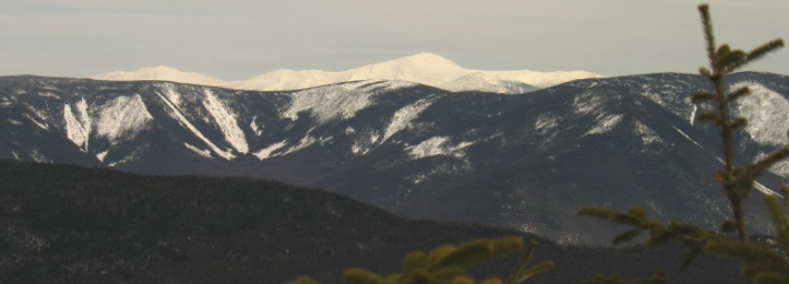
Soon I came to a graffitied blaze which confirmed that the party was pretty much over. As much as I wanted to vomit I had to laugh. In fact, in the summer this trail is very much like a flight of stairs...a very steep flight of very rocky stairs. Today, at least, the path was a nice smooth snowshoe track. Kind of like a well-maintained white sidewalk that happened to go straight up a mountain. And up I went. I was moving slowly before but now my progress was positively glacial. But I was making progress and the trail rose through beautiful evergreens. As noon approached I was even starting to feel better...still slow but at least I wasn't going to lose my lunch. Hmmm...lunch. I stopped and sat against a birch tree to eat one of my sandwiches and considered my situation. I had left a strict itinerary with Kevin and instructions to call New Hampshire Fish & Game if he did not hear from me by a certain time. Ordinarily I wouldn't do this but since I was soloing in winter, and expected to see no other souls on the trail because it was a weekday, I figured I should leave my plans with him. I calculated my panic time by assuming my slowest reasonable pace and then adding on about a half hour. I was already well behind even that timeline. I considered bailing at this point since I clearly would not be able to complete my plans. I decided to at least get up to Liberty Springs campsite so I could say I got somewhere. I reached the tenting area a little before 12:30 and knew that in summer it is less than half an hour to the summit of Liberty from this point. I decided to press on to the ridge and reassess there. I climbed up through shortening firs and came to the junction with the Franconia Ridge Trail about twenty minutes later. The weather was still fine although clouds had moved in, and I was sure I could make the summit and get back down before a S&R would be called for me so I continued on for the final 0.3 mile. Soon the trail began to open up and timberline was not far beyond. I came to the standard sign announcing my arrival at the Alpine Zone, but the sign which is usually at head height or higher, was down by my knees. Spring may be approaching but it is still winter in the mountains. I hauled myself up and over a few tricky ledges and gained a false summit to see the real crag not far away. Within moments I was greeted by the summit cairns and settled in to enjoy the view. Looking north along the ridge I spotted Mt. Lincoln which hides the slightly higher Lafayette from this angle. Over Lincoln's western shoulder were rolling hills of northwest New Hampshire and northeast Vermont with the distinctive Willoughby Gap on the horizon. Mt. Washington dominated the northeast. The view from Liberty is 360 degrees but I am always drawn to the eastern panorama beginning with Lincoln to the north and sweeping around to Flume just to the south, taking in the Pemigewasset wilderness. It was breezy and cold and the time was late so I headed down, stopping to admire the short cliff that forms one wall of Liberty's summit. On a sheltered shoulder just beIow the summit I was treated to a nice view of the cliffs of Cannon Mountain where the Old Man used to dwell, and one last look at Mt. Washington. After carefully negotiating the ledges just below the peak I soon returned to the trail junction. I turned left and headed down from the ridge. To my great surprise I met two people coming up just above the campsite who were both headed over to Flume...which had been my original objective. I shuffled slowly down the mountain, having forgotten my knee braces. Finally the steeps were behind me and I was a much happier hiker. When I got to the bike path I decided to take the Whitehouse trail back instead of walking the snowmachine track. Shortly before arriving at the car park I got a nice parting view through the trees of Liberty with Mt. Flume and its distinctive cliffs just behind it.
Soon I came to a graffitied blaze which confirmed that the party was pretty much over. As much as I wanted to vomit I had to laugh. In fact, in the summer this trail is very much like a flight of stairs...a very steep flight of very rocky stairs. Today, at least, the path was a nice smooth snowshoe track. Kind of like a well-maintained white sidewalk that happened to go straight up a mountain. And up I went. I was moving slowly before but now my progress was positively glacial. But I was making progress and the trail rose through beautiful evergreens. As noon approached I was even starting to feel better...still slow but at least I wasn't going to lose my lunch. Hmmm...lunch. I stopped and sat against a birch tree to eat one of my sandwiches and considered my situation. I had left a strict itinerary with Kevin and instructions to call New Hampshire Fish & Game if he did not hear from me by a certain time. Ordinarily I wouldn't do this but since I was soloing in winter, and expected to see no other souls on the trail because it was a weekday, I figured I should leave my plans with him. I calculated my panic time by assuming my slowest reasonable pace and then adding on about a half hour. I was already well behind even that timeline. I considered bailing at this point since I clearly would not be able to complete my plans. I decided to at least get up to Liberty Springs campsite so I could say I got somewhere. I reached the tenting area a little before 12:30 and knew that in summer it is less than half an hour to the summit of Liberty from this point. I decided to press on to the ridge and reassess there. I climbed up through shortening firs and came to the junction with the Franconia Ridge Trail about twenty minutes later. The weather was still fine although clouds had moved in, and I was sure I could make the summit and get back down before a S&R would be called for me so I continued on for the final 0.3 mile. Soon the trail began to open up and timberline was not far beyond. I came to the standard sign announcing my arrival at the Alpine Zone, but the sign which is usually at head height or higher, was down by my knees. Spring may be approaching but it is still winter in the mountains. I hauled myself up and over a few tricky ledges and gained a false summit to see the real crag not far away. Within moments I was greeted by the summit cairns and settled in to enjoy the view. Looking north along the ridge I spotted Mt. Lincoln which hides the slightly higher Lafayette from this angle. Over Lincoln's western shoulder were rolling hills of northwest New Hampshire and northeast Vermont with the distinctive Willoughby Gap on the horizon. Mt. Washington dominated the northeast. The view from Liberty is 360 degrees but I am always drawn to the eastern panorama beginning with Lincoln to the north and sweeping around to Flume just to the south, taking in the Pemigewasset wilderness. It was breezy and cold and the time was late so I headed down, stopping to admire the short cliff that forms one wall of Liberty's summit. On a sheltered shoulder just beIow the summit I was treated to a nice view of the cliffs of Cannon Mountain where the Old Man used to dwell, and one last look at Mt. Washington. After carefully negotiating the ledges just below the peak I soon returned to the trail junction. I turned left and headed down from the ridge. To my great surprise I met two people coming up just above the campsite who were both headed over to Flume...which had been my original objective. I shuffled slowly down the mountain, having forgotten my knee braces. Finally the steeps were behind me and I was a much happier hiker. When I got to the bike path I decided to take the Whitehouse trail back instead of walking the snowmachine track. Shortly before arriving at the car park I got a nice parting view through the trees of Liberty with Mt. Flume and its distinctive cliffs just behind it.